| Crops and Chlorpyrifos Usage in the Sacramento Valley Water Quality Coalition portion of the Delta | |
|
Author Scott Perrou American River College, Geography 350: Data Acquisition in GIS; Spring 2013 email: sperrou@arc.losrios.edu | |
|
Abstract The Sacramento Valley Water Quality Coalition delta area is a diversified agricultural community that has the potential to impact water quality downstream through pesticide applications to crops. Evaluations of pesticide usage and crop data can assist growers to manage their agricultural activities and maintain good water quality for all users. | |
|
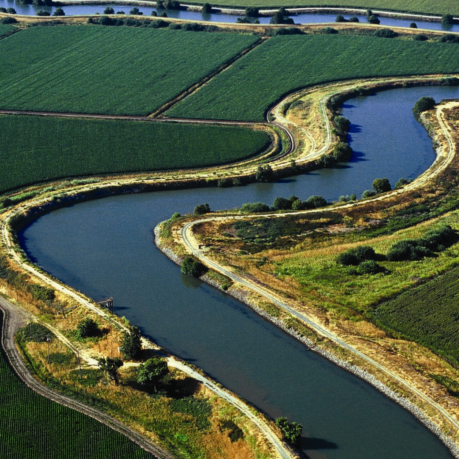
Introduction California’s Central Valley delta consists of remarkably productive agricultural areas. The delta encompasses approximately 738,000 acres of irrigated agricultural lands which grow a multitude of crops (which include alfalfa, asparagus, corn, fruit trees, grain, hay, pears, sugar beets, and tomatoes). These irrigated agricultural lands that convey waters off of their fields to surface waters, such as rivers and streams, potentially contribute a wide range of pollutants (i.e. pesticides, fertilizers, nutrients, salts, pathogens, sediment, etc…) to their receiving waters and ultimately into the delta. This report will evaluate crop data, pesticide use reporting data, and water pollution exceedances in the Sacramento Valley Water Quality Coalition (SVWQC) region of the delta to ascertain which farming commodities have the highest number of water pollution exceedances for chlorpyrifos. | |
|
Background California’s Central Valley delta is a unique and valuable resource. The delta receives runoff from over 40 percent of the State’s land area including flows from the Sacramento, San Joaquin, Mokelumne, Cosumnes, and Calaveras rivers. The delta provides habitat for flora and fauna; supports agricultural and recreational activities; and is center to water distribution throughout the State. For these uses and many others, the delta must preserve, improve, and restore water quality. | |
| The delta’s dominant land use is agriculture and started
back in the 1850’s with the reclamation of lowlands by the creation of levees. The underlying
fertile peat soils combined with the removal of tidal influence created an ideal and highly
productive agricultural landscape. Diverse arrays of agricultural crops are grown in the delta
and account for approximately $2 billion dollars to the local economy annually. |
|
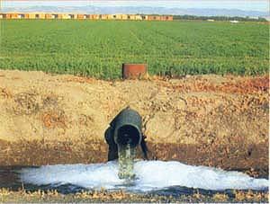
| California irrigated agriculture uses approximately 79 percent of diverted surface waters or
pumped groundwaters in California (DWR, 2012). The majority of delta crops are irrigated and
discharge waters back into the delta. Agricultural discharge waters can potentially have pollutants
in them and can adversely impact water quality and beneficial uses by all. |
|
|
To prevent agricultural discharges from impairing the delta waters that receive discharges,
the Central Valley Regional Water Quality Control Board Irrigated Lands Regulatory Program (ILRP)
regulates discharges from irrigated agricultural lands. ILRP regulation occurs by issuing waste
discharge requirements (WDRs) or conditional waivers of WDRs to growers which require water
quality monitoring and modification to agriculture operations if problems are found. Growers obtain regulatory coverage either by joining a coalition group or obtaining an Individual Permit. Coalition groups work directly with their member growers to assist in complying with requirements by monitoring, preparing regional plans to address water quality problems, and representing the growers as a whole. Growers with an individual permit are required to monitor, prepare plans, report, and make corrections individually to show agricultural operation water quality compliance. | |
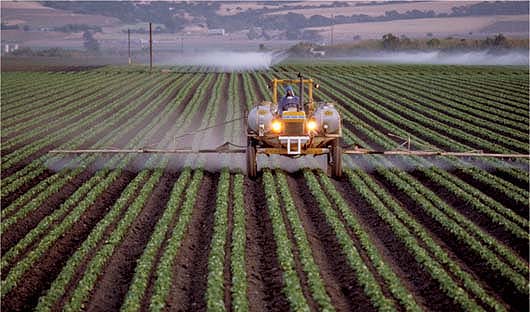
| Farmers are also required to report their pesticide usage
to their county agricultural commissioner, who in turn reports the data to the California Department
of Pesticide Regulations(DPR). DPR records the pesticide use reports in the California Pesticide
Information Portal (http://calpip.cdpr.ca.gov/main.cfm) and the information is directly accessible to
the public. |
|
|
The Sacramento Valley Water Quality Coalition (SVWQC) is composed of 8,600+ farmers and wetlands
managers and is supported by local farm bureaus, resource conservation districts, County
Agricultural Commissioners, and crop specialists with the University of California Cooperative
Extension. The SVWQC assists growers in the delta. The SVWQC portion of the delta (further referenced SVWQC delta) is located just east of Suisun Bay from the confluence of the Sacramento River and the San Joaquin River in Solano, Yolo, and Sacramento counties along the Sacramento River northeast to Sacramento. The SVWQC delta comprises 298,957 of the total 738,000 delta acres. This area cultivates many crops which apply chlorpyrifos, one of the most widely used organophosphate insecticides. Chlorpyrifos is a chemical of interest because it has potential acute toxic and neurological effects to humans, and toxic effects to amphibians, fish, and bees. My analysis compiled township/range/section data, chlorpyrifos use report data, crop data, and chlorpyrifos exceedance data for Solano, Yolo, and Sacramento counties within the SVWQC delta for the 2010 water year. | |
|
Methods Data and geospatial datasets were researched on the web and acquired from the USDA NRCS Geospatial Data Gateway (http://datagateway.nrcs.usda.gov/), the California Pesticide Information Portal (CalPIP) (http://calpip.cdpr.ca.gov/infodocs.cfm?page=aboutpur), the DWR California Water Plan Boundary Maps website (http://www.waterplan.water.ca.gov/maps/), the Water Board ILRP webpage, USDA National Agricultural Statistics Service’s Cropscape (http://nassgeodata.gmu.edu/CropScape), and the SVWQC website (http://www.svwqc.org/). The acquired data layers were first manipulated to only show the legal delta within the SVWQC boundary. The SVWQC delta boundary was downloaded into Cropscape and the resulting output displayed the SVWQC delta crops. The resulting data was exported as a shapefile to be analyzed. CalPIP geospatial datasets were manipulated and then selected within the SVWQC delta area. These specific areas, where chlorpyrifos was applied, were created into a shapefile to delineate the areas of interest. The dataset for the 2010 SVWQC chlorpyrifos exceedances was in Excel format so the data was prepared and created as a shapefile. Then the exceedance sites layer was added to the CalPIP pesticide use layer. Lastly the SVWQC delta Cropscape layer was clipped with the CalPIP data to give the crops found in the chlorpyrifos use reported areas. The resulting crop layer was used to analyze the datasets and determine the most abundant crops in the chlorpyrifos use areas by looking at the attribute table and summarizing the counts of specific crops. This data was then manipulated by multiplying the cell size (900) in square meters by the count by the conversion factor (0.000247105381467) to give you acreages for each crop. Then sorting the resulting field data in descending order, to give you the crop with the highest acreages to the crops with the lowest acreages. | |
|
Results
| |
|
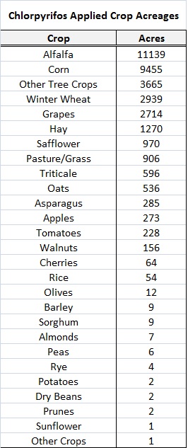
The crop results can be seen in the table. The data sources were
limited especially for the water quality monitoring data. More current data is not currently available.
|
|
Maps Map 1.Solano, Yolo, and Sacramento Counties Delta Pesticide Usage | |
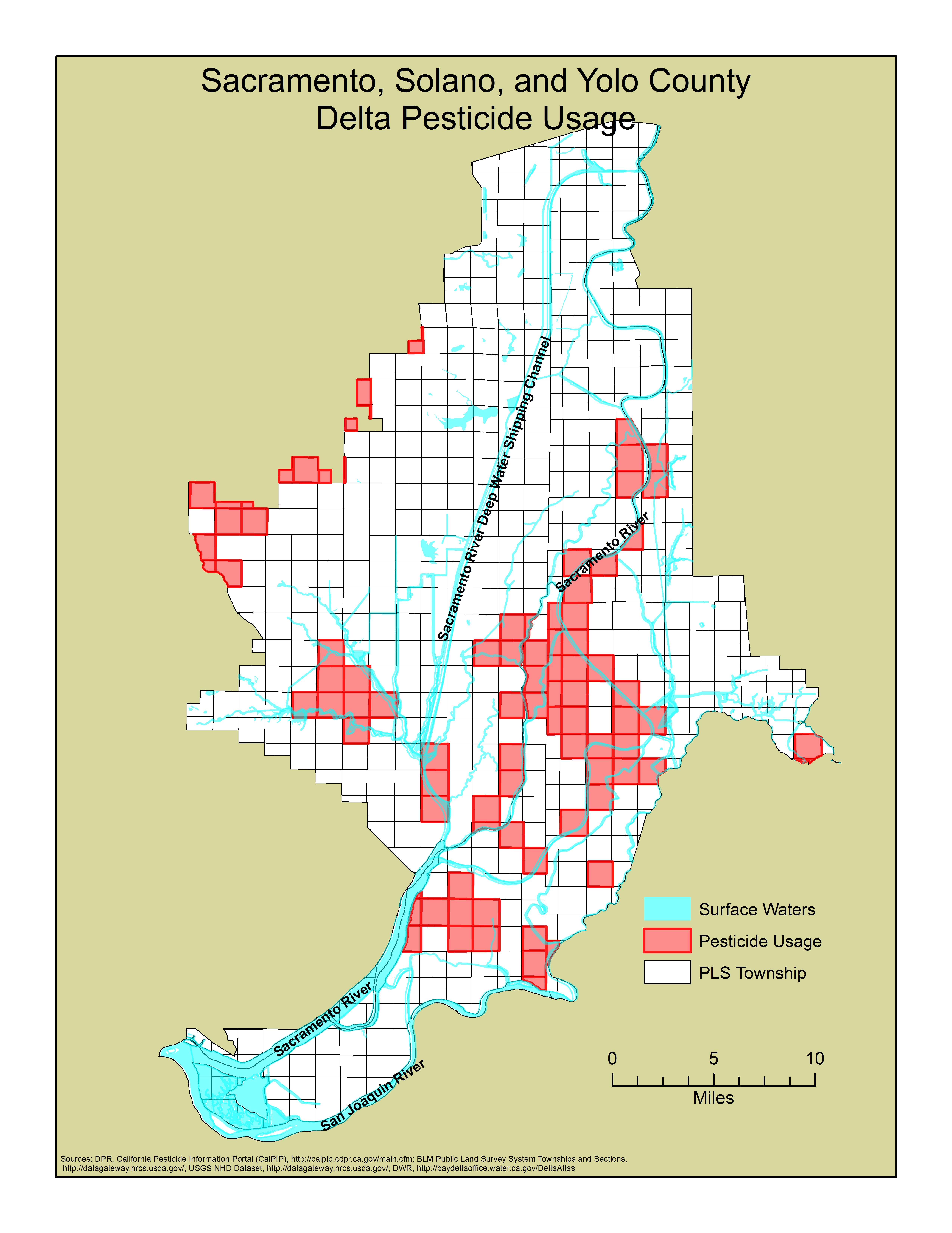
| |
|
Map 2.Solano, Yolo, and Sacramento Counties Delta Observed Chlorpyrifos Exceedances | |
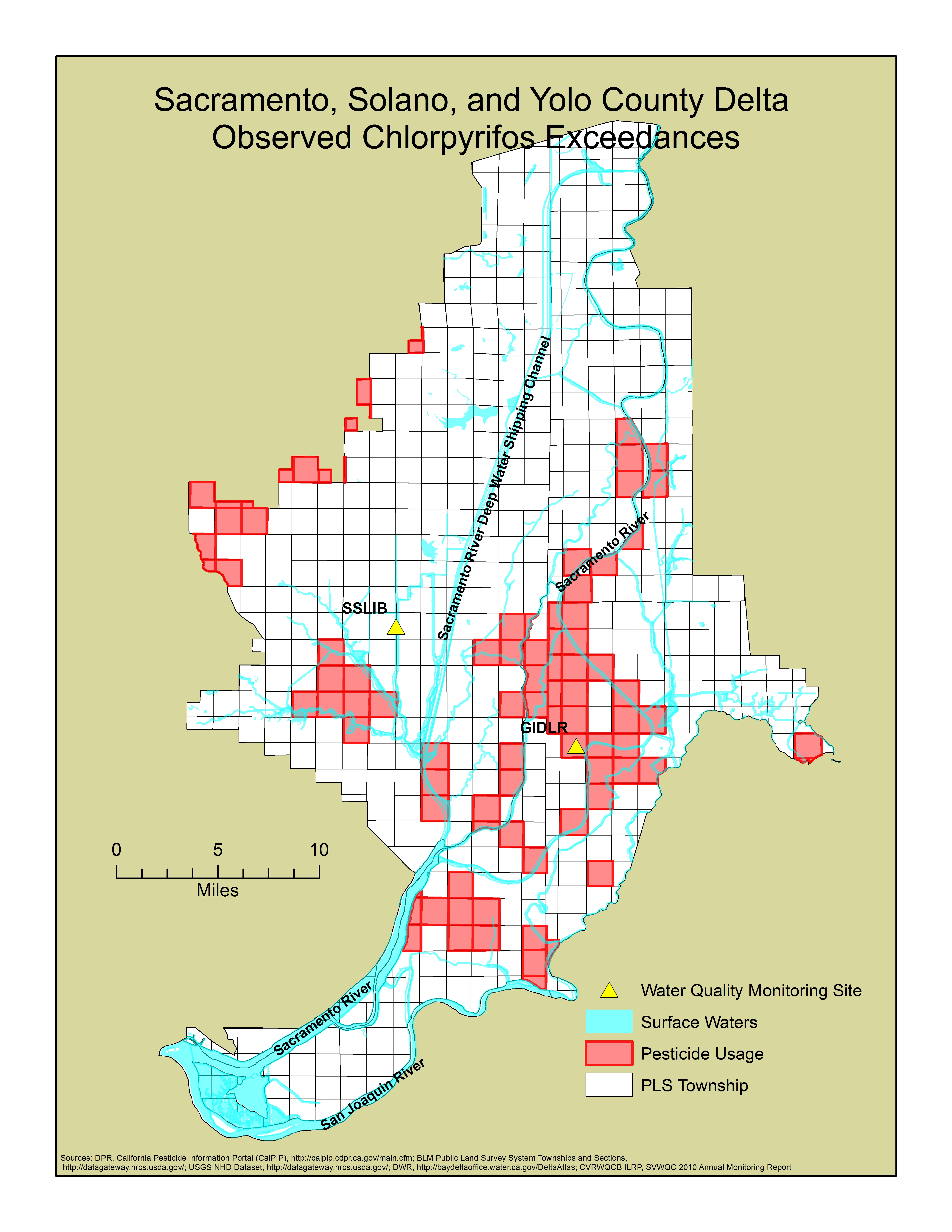
| |
|
Map 3.Solano, Yolo, and Sacramento Counties Delta Crops | |
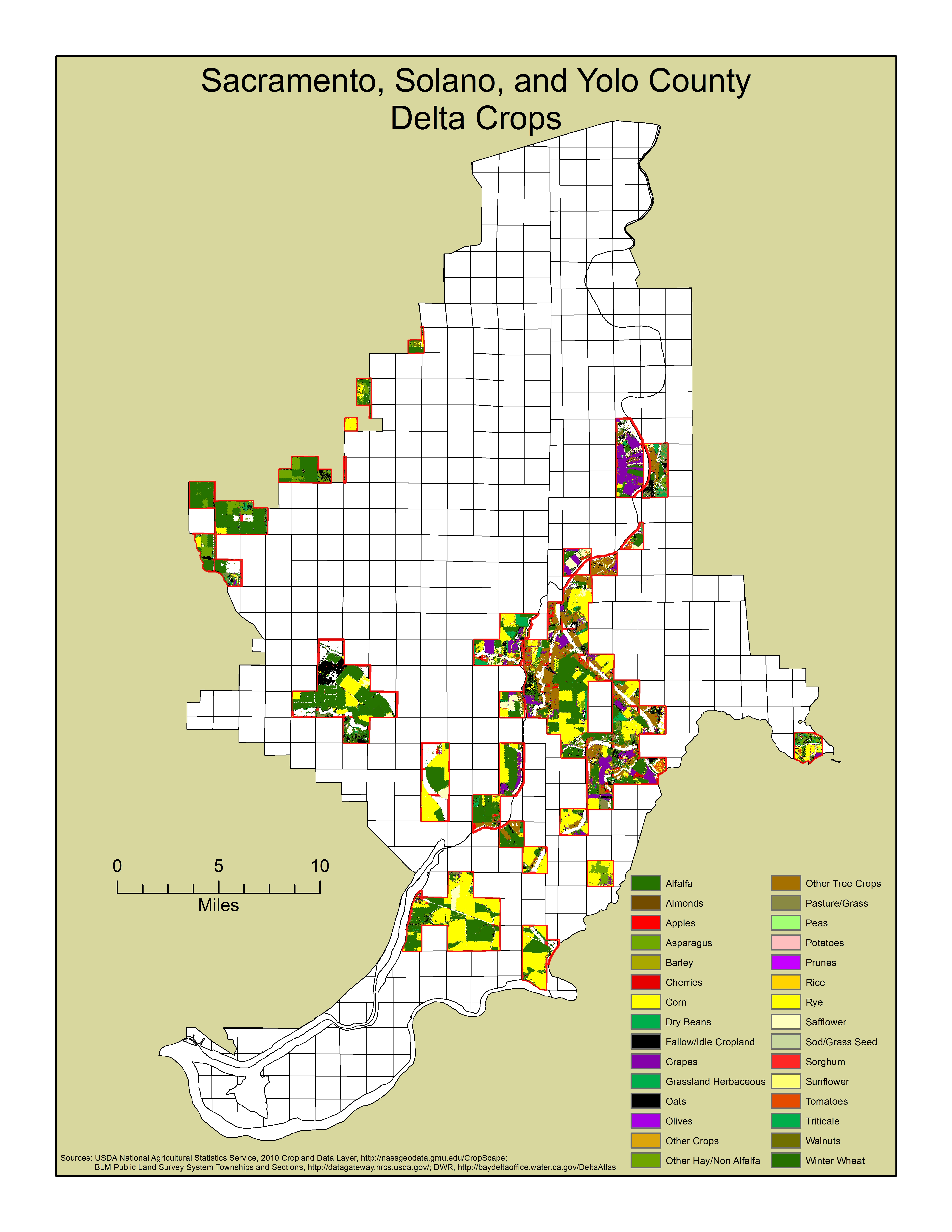
| |
|
Analysis Analysis of the results indicates that the top 5 crops
that are produced in areas where chloropyrifos has been applied and there are exceedances are: alfalfa,
corn, tree crops, winter wheat, and grapes. For the GIDLR monitoring location, the data appears
plausible since the areas upstream and surrounding the site applied chlorpyrifos. However, more
information is needed to resolve the exceedances at the SSLIB site since there are no evident applications
of chlorpyrifos in the adjacent areas.
| |
|
Conclusions The analysis points out the crops with the highest amount of
chlorpyrifos applied acreages and this could be valuable to the coalition and growers for outreach purposes.
This would allow targeted outreach to specific commodity groups that can more likely make a change to
agricultural practices that would allow for direct improvements to water quality in the delta.This analysis was a very basic first step but it could be expanded in the future to include; temporal qualities for the application areas; a hydrological assessment of the SVWQC delta to include the upland areas that may contribute to exceedances (i.e. SSLIB results); and more sampling sites . These additional analyses could be added to create a better understanding of the water quality impacts from agricultural pesticide applications in the SVWQC delta. | |
|
References
California Department of Water Resources 2013. Where Rivers Meet-The Sacramento-San Joaquin Delta.
http://www.water.ca.gov/swp/delta.cfm DWR, 2012. Agricultural Water Use. California Department of Water Resources. http://www.water.ca.gov/wateruseefficiency/agricultural/ DWR. Sacramento-San Joaquin Delta Overview. http://baydeltaoffice.water.ca.gov/sdb/tbp/deltaoverview/index.cfm Galloway, D.L., Jones, D.R., and Ingebritsen, S.E. 1999. Land subsidence in the United States: U.S. Geological Survey Circular 1182, 175 p. http://pubs.er.usgs.gov/publication/cir1182 or at: http://pubs.usgs.gov/circ/circ1182/pdf/11Delta.pdf Restore The Delta, 2012. Overview of Delta Agriculture. Stockton, CA. http://www.restorethedelta.org/about-the-delta/overview-of-delta-agriculture/ Sacramento Valley Water Quality Coalition 2012. Annual Monitoring Report 2010. http://www.svwqc.org/ SWRCB, 2013. Irrigated Lands Regulatory Program. 2013. http://www.swrcb.ca.gov/water_issues/programs/agriculture/ and http://www.waterboards.ca.gov/centralvalley/water_issues/irrigated_lands/ USDA, National Agricultural Statistics Service 2013. http://nassgeodata.gmu.edu/CropScape/ USDA NRCS Geospatial Data Gateway 2013. http://datagateway.nrcs.usda.gov/ Wikipedia, 2013. Chlorpyrifos. Last edited on 27 April 2013. http://en.wikipedia.org/wiki/Chlorpyrifos | |